
Partly Sunny or Partly Cloudy
If you know me, you know I’m a “partly sunny” kind of guy – always seeing the positive open opportunities ahead (especially with my “impossible” golf shots from the woods – “don’t worry, I got this!”). That positive outlook is shared by my gang here at KHT, always encouraging each other to find the “sunny” spot – and to keep trying when working on your PIA (pain in the @%$) Jobs! One of the fun advantages I have living in Cleveland are the different cloud formations we get to see throughout the year – from wispy cirrus formations to big puffy cumulus cotton balls (I always find some special animals in them) to the super dark rain/snow clouds I see coming in over the lake (I’m really lucky, as my office here at KHT World headquarters looks out over Lake Erie). I love seeing the storm clouds forming out west over the water and then watching how they move in with the rain front (and sometimes a lightning show). Many of my boater friends tell me how quickly the weather can change when they are out on the lake – beautiful sunny fishing days can quickly turn into scrambles to the shore. I did some digging online to refresh my memory of the different cloud formations and the weather tips they provide, and just had to share. I’m looking forward to lying down on the driveway with the grandkids and picking out different shapes in the clouds this weekend (the grass is way too wet!) I’m always amazed by what the little munchkins “see” in the clouds! – and recommend you give it a try. Thanks to Google, theweatherchannel.com and YouTube for the info. Enjoy!
By popular demand, we’re now sharing guides for the previous week’s logo contest!
Every Friday, scroll to the bottom of the post to review last week’s guide and see if we managed to stump you.
Awesome tune to enjoy while reading.
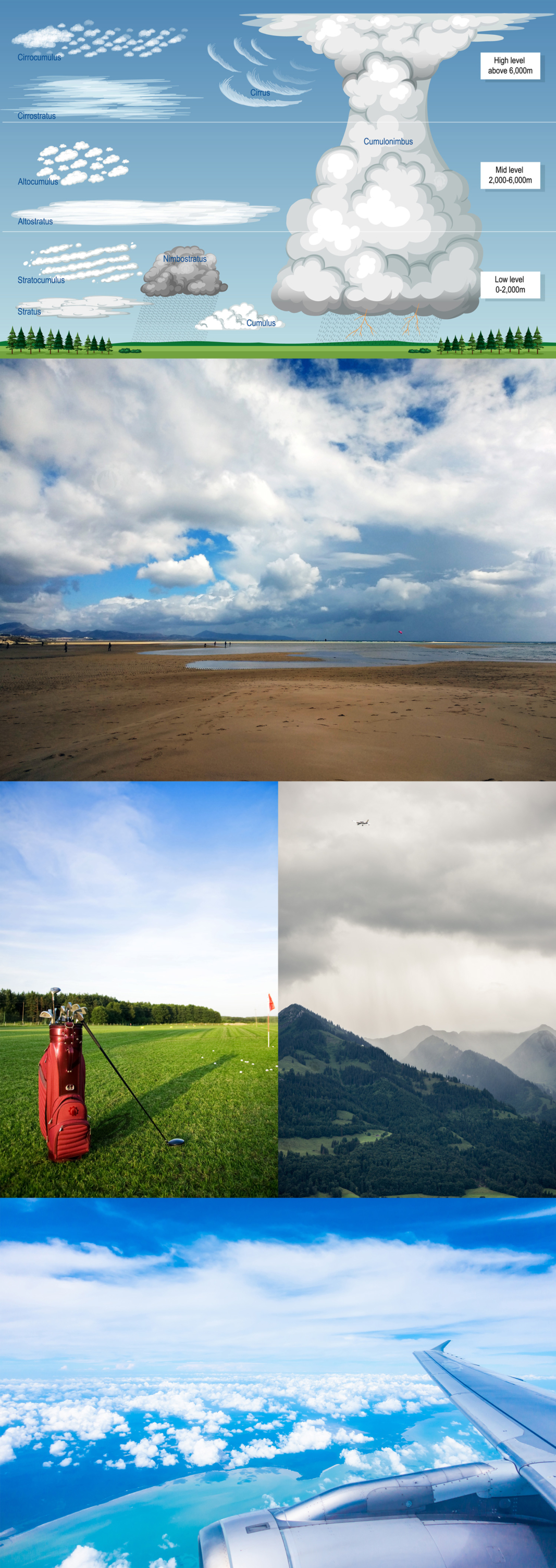
All clouds form as a result of saturation – that’s when the air contains so much water vapor that it begins producing liquid or ice. Clouds that look like cartoon cotton balls or cauliflower are made up of tiny liquid water droplets. These are fair-weather clouds that form when the Sun warms the ground and the warm air rises. You’ll often see them on humid summer days.
If the air is particularly warm and humid, and the atmosphere above is much colder, cumulus clouds can rapidly grow vertically into cumulonimbus. When the edges of these clouds look especially crisp, it’s a sign that heavy rain or snow may be imminent.
To get your cloud spotting, naming (and pronunciation) correct, here’s a guide that will help you impress your friends at your favorite watering hole!
- Cirrus (SIR-us) – Latin for “curl” or “wisp of hair” (because these clouds look wispy).
- Cumulus (KYOO-myoo-lus) – Latin for “heap” or “pile” (they look like puffy piles of cotton).
- Stratus (STRAY-tus or STRAH-tus) – Latin for “layer” (these clouds spread out like a blanket).
- Nimbus (NIM-bus) – Latin for “rain” (clouds with this name bring precipitation).
When clouds form thick layers, we mix root words together and add the word “stratus,” or “layer,” to the name. Stratus can occur just above the ground, or a bit higher up – we call it altostratus then. It can occur even higher and become cirrostratus, or a layer of ice clouds.
- Cirrostratus (SIR-oh-STRAY-tus) – A high, thin layer of clouds.
- Cumulonimbus (KYOO-myoo-lo-NIM-bus) – A big, puffy cloud that brings storms.
- Altostratus (AL-toe-STRAY-tus) – A middle-layer blanket cloud.
If you are traveling, or lucky enough to live near mountains, there are a number of other unique and beautiful cloud types that can form as air rises over mountain slopes and other topography. Lenticular clouds, for example, can look like flying saucers hovering just above, or near, mountaintops. Lenticular clouds can actually form far from mountains, as wind over a mountain range creates an effect like ripples in a pond. Rarer are banner clouds, which form from horizontally spinning air on one side of a mountain.
You might have looked up at the sky and noticed one layer of clouds moving in a different direction from another. Clouds move along with the wind, so what you’re seeing is the wind changing direction with height. Cirrus clouds at the level of the jet stream – often about 6 miles above the ground – can sometimes move at over 200 miles per hour, but because they are so high up, it’s often hard to tell how fast they are moving.
Fun Fact: Cumulus clouds are the ones kids often imagine as animals or shapes in the sky. Plus, A cumulus cloud can weigh over 1 million pounds, but it stays afloat because it’s spread over a vast area.
Now, about that golf shot – “see the tiny opening in between those branches? If I hit it right, it will go out about 50 yards, bend towards the hole, and check on the green… better stand back.”
How did you do on last week’s logo contest?
Check out our logo guide for the “Being the Best at What You Do” post here!


Leave a Reply
Want to join the discussion?Feel free to contribute!