Honey, Are You Sure We’re Going the Right Way?
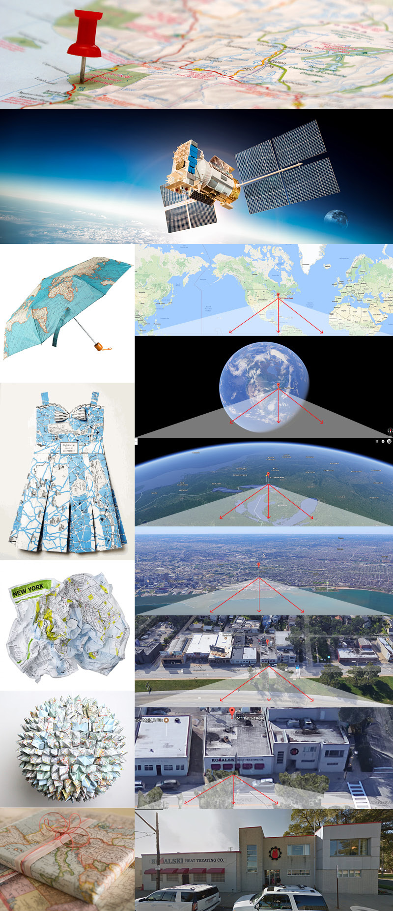
(top) How we used to pinpoint our location was with a push pin, marker, crayin, etc. (second from top) How we do it now. GPS satellites cost billions of dollars more than a push pin but, these days, both are at our finger tips. (left column) Maps aren’t totally out of style. (or are they?) What people are doing with maps these days: Umbrella graphics, paper dress art, a guy in Germany is selling crumpled maps in a bag of major world cities (haha…), incredible paper sculpture art and of course…wrapping paper. (right column) Go to Google Maps, put in 3611 Detroit Ave Cleveland, Ohio 44113. Those satellites will triangulate the location of Kowalski Heat Treating. Then you can go from maps to satellite view and keep zooming in to my location in 3D and finally the street view. Technology is simply and literally out of this world.
When we were kids, Mom and Dad were really superheros. They’d think nothing of packing up the car, loading in the kids, and heading off for our end of the summer vacation. I can remember Mom fussing with the road maps, trying to follow the red line they drew on the maps. Of course, Dad at the wheel, we’d occasionally hear “are you sure this is the way”? By the time my baby brother and sister were 21 years old, they had actually visited all 50 states on family vacations! It was nothing for us to go on cross country trips of exploration and wonder! Thinking back, I can say that I have been blessed to have been able to visit 38 states across this incredibly beautiful country that is filled with caring and generous people along with being able to sample amazing food! Today, we are blessed with amazing GPS technology, in our cars, on our phones, or stuck to the windshield. We can preprogram the routes, and then listen to a nice lady tell us where to turn, or even suggest shortcuts. So, with my investigative curiosity peaked, I dove in to learn more, and of course, share with you. Enjoy, and thanks to howthingswork.com and Wikipedia for the extended history lesson.
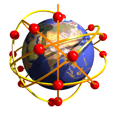
- The Global Positioning System (GPS) is a network of about 30 satellites orbiting the Earth at an altitude of 20,000 km. The system was originally developed by the US government for military navigation but now anyone with a GPS device, be it a SatNav, mobile phone or handheld GPS unit, can receive the radio signals that the satellites broadcast.
- The GPS system does not require the user to transmit any data, and it operates independently of any telephonic or internet reception, though these technologies can enhance the usefulness of the GPS positioning information. The GPS system provides critical positioning capabilities to military, civil, and commercial users around the world. The United States government created the system, maintains it, and makes it freely accessible to anyone with a GPS receiver.
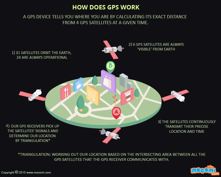
- Wherever you are on the planet, at least four GPS satellites are ‘visible’ at any time. Each one transmits information about its position and the current time at regular intervals. These signals, travelling at the speed of light, are intercepted by your GPS receiver, which calculates how far away each satellite is based on how long it took for the messages to arrive. Once it has information on how far away at least three satellites are, your GPS receiver can pinpoint your location using a process called trilateration.
- The technology works this way – Imagine you are standing somewhere on Earth with three satellites in the sky above you. If you know how far away you are from satellite A, and do the same for satellites B and C, you can work out your location by seeing where the three circles intersect. This is just what your GPS receiver does, although it uses overlapping spheres rather than circles. The more satellites there are above the horizon the more accurately your GPS unit can determine where you are.
- GPS satellites have atomic clocks on board to keep accurate time. General and Special Relativity however predict that differences will appear between these clocks and an identical clock on Earth. General Relativity predicts that time will appear to run slower under stronger gravitational pull – the clocks on board the satellites will therefore seem to run faster than a clock on Earth. Furthermore, Special Relativity predicts that because the satellites’ clocks are moving relative to a clock on Earth, they will appear to run slower. The whole GPS network makes allowances for these effects – proof that Relativity has a real impact.
This animated GIF is from a fabulous learning site for kids 14 and under called MOCOMI. Check it out HERE. It’s great for adults (parents, teachers…) who want to help kids understand the world around them.
- The GPS project was launched in the United States in 1973 to overcome the limitations of previous navigation systems, integrating ideas from several predecessors, including a number of classified engineering design studies from the 1960s. The S. Department of Defensedeveloped the system, which originally used 24 satellites for use by the United States military and became fully operational in 1995. It was allowed for civilian use in the 1980s. Roger L. Easton of the Naval Research Laboratory, Ivan A. Getting of The Aerospace Corporation, and Bradford Parkinson of the Applied Physics Laboratory are credited with inventing it.
- The design of GPS is based partly on similar ground-based radio-navigation systems, such as LORAN and the Decca Navigator, developed in the early 1940s and used by the British Royal Navy during World War II. Friedwardt Winterberg proposed a test of general relativity — detecting time slowing in a strong gravitational field using accurate atomic clocks placed in orbit inside artificial satellites.
- When the Soviet Union launched the first man-made satellite, Sputnik 1, in 1957, two American physicists, William Guier and George Weiffenbach, at Johns Hopkins’s Applied Physics Laboratory (APL), decided to monitor Sputnik’s radio transmissions. Within hours they realized that, because of the Doppler effect, they could pinpoint where the satellite was along its orbit. The Director of the APL gave them access to their UNIVAC to do the heavy calculations required.
- The next spring, Frank McClure, the deputy director of the APL, asked Guier and Weiffenbach to investigate the inverse problem — pinpointing the user’s location, given that of the satellite. (At the time, the Navy was developing the submarine-launched Polaris missile, which required them to know the submarine’s location.) This led them and APL to develop the TRANSIT system
- The first satellite navigation system, TRANSIT, used by the United States Navy, was successfully tested in 1960. It used a constellation of five satellites and could provide a navigational fix approximately once per hour. In 1967, the U.S. Navy developed the Timation satellite, which proved the feasibility of placing accurate clocks in space, a technology required by GPS.
- In the 1970s, the ground-based OMEGA navigation system, based on phase comparison of signal transmission from pairs of stations, became the first worldwide radio navigation system. Limitations of these systems drove the need for a more universal navigation solution with greater accuracy.
- During the Cold War arms race, the nuclear threat to the existence of the United States was the one need that did justify this cost in the view of the United States Congress. This deterrent effect is why GPS was funded. It is also the reason for the ultra-secrecy at that time. The nuclear triad consisted of the United States Navy’s submarine-launched ballistic missiles (SLBMs) along with United States Air Force (USAF) strategic bombers and intercontinental ballistic missiles (ICBMs). Considered vital to the nuclear deterrence posture, accurate determination of the SLBM launch position was a force multiplier. Precise navigation would enable United States ballistic missile submarines to get an accurate fix of their positions before they launched their SLBMs.
- The USAF, with two thirds of the nuclear triad, also had requirements for a more accurate and reliable navigation system. The Navy and Air Force were developing their own technologies in parallel to solve what was essentially the same problem.
- To increase the survivability of ICBMs, there was a proposal to use mobile launch platforms (comparable to the Russian SS-24 and SS-25) and so the need to fix the launch position had similarity to the SLBM situation.
- In 1960, the Air Force proposed a radio-navigation system called MOSAIC (Mobile System for Accurate ICBM Control) that was essentially a 3-D LORAN. A follow-on study, Project 57, was worked in 1963 and it was “in this study that the GPS concept was born.” That same year, the concept was pursued as Project 621B, which had “many of the attributes that you now see in GPS” and promised increased accuracy for Air Force bombers as well as ICBMs.
- Another important predecessor to GPS came from a different branch of the United States military. In 1964, the United States Army orbited its first Sequential Collation of Range (SECOR) satellite used for geodetic surveying. The SECOR system included three ground-based transmitters from known locations that would send signals to the satellite transponder in orbit. A fourth ground-based station, at an undetermined position, could then use those signals to fix its location precisely. The last SECOR satellite was launched in 1969.
- With these parallel developments in the 1960s, it was realized that a superior system could be developed by synthesizing the best technologies from 621B, Transit, Timation, and SECOR in a multi-service program. During Labor Day weekend in 1973, a meeting of about twelve military officers at the Pentagon discussed the creation of a Defense Navigation Satellite System (DNSS). It was at this meeting that the real synthesis that became GPS was created. Later that year, the DNSS program was named Navstar, or Navigation System Using Timing and Ranging. With the individual satellites being associated with the name Navstar (as with the predecessors Transit and Timation), a more fully encompassing name was used to identify the constellation of Navstar satellites.
- The effects of the ionosphere on radio transmission through the ionosphere was investigated within a geophysics laboratory of Air Force Cambridge Research Laboratory. Located at Hanscom Air Force Base, outside Boston, the lab was renamed the Air Force Geophysical Research Lab (AFGRL) in 1974. AFGRL developed the Klobuchar Model for computing ionospheric corrections to GPS location. Of note is work done by Australian Space Scientist Elizabeth Essex-Cohen at AFGRL, concerned with the curving of the path of radio waves traversing the ionosphere from NavSTAR satellites.
- After Korean Air Lines Flight 007, a Boeing 747 carrying 269 people, was shot down in 1983 after straying into the USSR’s prohibited airspace, in the vicinity of Sakhalin and Moneron Islands, President Ronald Reagan issued a directive making GPS freely available for civilian use, once it was sufficiently developed, as a common good. The first Block II satellite was launched on February 14, 1989, and the 24th satellite was launched in 1994.
- Since its deployment, the U.S. has implemented several improvements to the GPS service including new signals for civil use and increased accuracy and integrity for all users, all the while maintaining compatibility with existing GPS equipment. Modernization of the satellite system has been an ongoing initiative by the U.S. Department of Defense through a series of satellite acquisitions to meet the growing needs of the military, civilians, and the commercial market.
If you have any “fun” map or GPS stories, be sure to send ‘em to me at skowalski@khtheat.com.


Leave a Reply
Want to join the discussion?Feel free to contribute!