Road Trip!
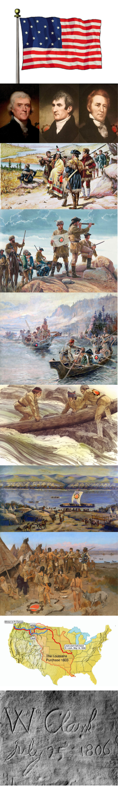
Back when there were 15 stars & stripes on our glorious flag, President Thomas Jefferson commissioned Captain Meriwether Lewis & Second Lieutenant William Clark on an expedition that would change our country forever. Wouldn’t it be great to have seen the country back in those times? Some of the paintings above give a flavor of the beauty and how tough the going really was. And thanks to that expedition, I can use a car to take my family to see our beautiful US of A. :)) Really interesting read.
Ever go for a walk, a run, or jump in the car and head off, not really knowing what’s ahead, or where you’ll end up? I do, and really love the “unknown”. Back in the very early days of our Nation, it was called an expedition. No, not the car – the old-fashioned kind, where incredibly brave men (and women) packed up their stuff, gathered up some wagons, boats, grub and strong animals and started exploring. No maps, no GPS – just a direction – talk about a PIA (Pain in the @%$) Job! On the surface, it seems pretty reasonable, right … “hey guys, just go in this direction and see where it takes you”. As a kid, I used to love exploring the neighborhoods on my bike – go down a new street, find a different way home, cut through some woods or just peddle around looking for some of my buds. Not much risk involved really. Dad and Mom on the other hand would take the family (all of us!) on incredible driving road trips, eventually a few of my siblings have actually been to all 50 states! But when the President of the United States says he’s looking for “the most direct and practicable water communication across this continent, for the purposes of commerce”, and commissions your team to go … well, I guess you go. Today marks the day when The Corps of Discovery departed from Camp Dubois (Camp Wood) at 4 pm on May 14, 1804. Under William Clark’s command, they traveled up the Missouri River in their keelboat and two pirogues to St. Charles, Missouri, where Meriwether Lewis joined them six days later. The expedition set out the next afternoon, May 21, where as many as 45 members, including the officers, enlisted military personnel, civilian volunteers, and support team headed West. Here is just some of the history provided on Wikipedia – it’s fascinating! I left in a lot of the links, as the story has so many “legs” to it. Enjoy. And get on your bike this weekend and go exploring!
The Lewis and Clark Expedition from August 31, 1803, to September 25, 1806, also known as the Corps of Discovery Expedition, was the United States expedition to cross the newly acquired western portion of the country after the Louisiana Purchase. The Corps of Discovery was a select group of U.S. Army and civilian volunteers under the command of Captain Meriwether Lewis and his close friend Second Lieutenant William Clark. The expedition made its way westward, and crossed the Continental Divide of the Americas before reaching the Pacific Coast.
President Thomas Jefferson commissioned the expedition shortly after the Louisiana Purchase in 1803 to explore and to map the newly acquired territory, to find a practical route across the western half of the continent, and to establish an American presence in this territory before European powers attempted to establish claims in the region. The campaign’s secondary objectives were scientific and economic: to study the area’s plants, animal life, and geography, and to establish trade with local Native American tribes.
For years, Thomas Jefferson read accounts about the ventures of various explorers in the western frontier, and consequently had a long-held interest in further exploring this mostly unknown region of the continent. In the 1780s, while Minister to France, Jefferson met John Ledyard in Paris and they discussed a possible trip to the Pacific Northwest. Jefferson had also read Captain James Cook‘s A Voyage to the Pacific Ocean (London, 1784), an account of Cook’s third voyage, and Le Page du Pratz’s The History of Louisiana (London, 1763), all of which greatly influenced his decision to send an expedition.
Two years into his presidency, Jefferson asked Congress to fund an expedition through the Louisiana territory to the Pacific Ocean. He did not attempt to make a secret of the Lewis and Clark expedition from Spanish, French, and British officials, but rather claimed different reasons for the venture. He used a secret message to ask for funding due to poor relations with the opposition Federalist Party in Congress (wow, what a surprise – funding battles in Washington). Congress subsequently appropriated $2,324 for supplies and food, (that’s it? – obviously a Kowalski was not on the food list) the appropriation of which was left in Lewis’s charge.
In 1803, Jefferson commissioned the Corps of Discovery and named Army Captain Meriwether Lewis its leader, who then invited William Clark to co-lead the expedition with him. Lewis demonstrated remarkable skills and potential as a frontiersman, and Jefferson made efforts to prepare him for the long journey ahead as the expedition was gaining approval and funding.
Jefferson explained his choice of Lewis: (I love this description) “It was impossible to find a character who to a complete science in botany, natural history, mineralogy & astronomy, joined the firmness of constitution & character, prudence, habits adapted to the woods & a familiarity with the Indian manners and character, requisite for this undertaking. All the latter qualifications Capt. Lewis has.”
A keelboat used for the first year of the journey was built near Pittsburgh, Pennsylvania, in the summer of 1803 at Lewis’s specifications. The boat was completed on August 31 and was immediately loaded with equipment and provisions. Lewis and his crew set sail that afternoon, traveling down the Ohio River to meet up with Clark near Louisville, Kentucky in October 1803 at the Falls of the Ohio. Their goals were to explore the vast territory acquired by the Louisiana Purchase and to establish trade and US sovereignty over the Native Americans along the Missouri River. Jefferson also wanted to establish a US claim of “discovery” to the Pacific Northwest and Oregon territory by documenting an American presence there before European nations could claim the land.
Jefferson’s instructions to the expedition stated: “The object of your mission is to explore the Missouri River, & such principle stream of it, as, by its course and communication with the waters of the Pacific ocean, whether the Columbia, Oregon, Colorado or any other river may offer the most direct & practicable water communication across this continent for the purpose of commerce.”
The US mint prepared special silver medals with a portrait of Jefferson and inscribed with a message of friendship and peace, called Indian Peace Medals. The soldiers were to distribute them to the tribes that they met. The expedition also prepared advanced weapons to display their military firepower. Among these was an Austrian-made .46 caliber Girandoni air rifle, a repeating rifle with a 20-round tubular magazine that was powerful enough to kill a deer. The expedition was prepared with flintlock firearms, knives, blacksmithing supplies, and cartography equipment and also carried flags, gift bundles, medicine, and other items that they would need for their journey.
The route of Lewis and Clark’s expedition took them up the Missouri River to its headwaters, then on to the Pacific Ocean via the Columbia River, and it may have been influenced by the purported transcontinental journey of Moncacht-Apé . Jefferson had a copy of Le Page’s book in his library detailing Moncacht-Apé’s itinerary, and Lewis carried a copy with him during the expedition. Le Page’s description of Moncacht-Apé’s route across the continent neglects to mention the need to cross the Rocky Mountains, (oops, a small detail) and it might be the source of Lewis and Clark’s mistaken belief that they could easily carry boats from the Missouri’s headwaters to the westward-flowing Columbia.
From St. Charles, the expedition followed the Missouri through what is now Kansas City, Missouri, and Omaha, Nebraska. On August 20, 1804, Sergeant Charles Floyd died, among the first to sign up with the Corps of Discovery and was the only member to die during the expedition. He was buried at a bluff by the river, now named after him, in what is now Sioux City, Iowa..
During the final week of August, Lewis and Clark reached the edge of the Great Plains During the expedition, the group established relations with about two dozen Indian nations, without whose help the expedition would have risked starvation during the harsh winters or become hopelessly lost in the vast ranges of the Rocky Mountains.
After the expedition had set up camp, nearby Indians came to visit in fair numbers, some staying all night. For several days, Lewis and Clark met in council with Mandan chiefs. Here they met a French-Canadian fur trapper named Toussaint Charbonneau, and his young Shoshone wife Sacagawea. Charbonneau at this time began to serve as the expedition’s translator. Peace was established between the expedition and the Mandan chiefs with the sharing of a Mandan ceremonial pipe.
By April 25, Captain Lewis wrote his progress report of the expedition’s activities and observations of the Native American nations they have encountered to date: A Statistical view of the Indian nations inhabiting the Territory of Louisiana, which outlined the names of various tribes, their locations, trading practices, and water routes used, among other things. President Jefferson would later present this report to Congress.
They followed the Missouri to its headwaters, and over the Continental Divide at Lemhi Pass. In canoes, they descended the mountains by the Clearwater River, the Snake River, and the Columbia River, past Celilo Falls, and past what is now Portland, Oregon, at the meeting of the Willamette and Columbia Rivers. Lewis and Clark used William Robert Broughton’s 1792 notes and maps to orient themselves once they reached the lower Columbia River. The sighting of Mount Hood confirmed that the expedition had almost reached the Pacific Ocean.
The expedition sighted the Pacific Ocean for the first time on November 7, 1805, arriving two weeks later, where the expedition faced its second bitter winter camped on the north side of the Columbia River, in a storm-wracked area. Lack of food was a major factor. The elk, the party’s main source of food, had retreated from their usual haunts into the mountains, and the party was now too poor to purchase enough food from neighboring tribes.
On the south side of the Columbia River, 2 miles upstream on the west side of the Netul River (now Lewis and Clark River), they constructed Fort Clatsop. They did this not just for shelter and protection, but also to officially establish the American presence there, with the American flag flying over the fort. During the winter at Fort Clatsop, Lewis committed himself to writing and was determined to remain at the fort until April 1 but was still anxious to move out at the earliest opportunity. By March 22, the stormy weather had subsided and the following morning, on March 23, 1806, the journey home began.
They made their way to Camp Chopunnish in Idaho, along the north bank of the Clearwater River, where the members of the expedition collected 65 horses in preparation to cross the Bitterroot Mountains, lying between modern-day Idaho and western Montana. However, the range was still covered in snow, which prevented the expedition from making the crossing.
As the expedition encountered the various Native American tribes during the course of their journey, they observed and recorded information regarding their lifestyles, customs and the social codes they lived by, as directed by President Jefferson. By western standards, the Native American way of life seemed harsh and unforgiving as witnessed by members of the expedition.
One of the primary customs that distinguished Native American cultures from those of the West was that it was customary for the men to take on two or more wives if they were able to provide for them and often took on a wife or wives who were members of the immediate family circle. Sacagawea, sometimes called Sakajawea or Sakagawea was a Shoshone Native American woman who arrived with her husband Toussaint Charbonneau on the expedition to the Pacific Ocean.
On February 11, 1805, a few weeks after her first contact with the expedition, Sacagawea went into labor which was slow and painful, so the Frenchman Charbonneau suggested she be given a potion of rattlesnake’s rattle to aid in her delivery (yum – Lewis luckily happened to have some snake’s rattle with him). A short time after administering the potion, she delivered a healthy boy who was given the name Jean Baptiste Charbonneau. Sacagawea was not the guide for the Expedition, but was important to them as an interpreter and in other ways, as she played an important role in diplomatic relations by talking to chiefs, easing tensions, and giving the impression of a peaceful mission.
The Corps met their objective of reaching the Pacific, mapping and establishing their presence for a legal claim to the land. They established diplomatic relations and trade with at least two dozen indigenous nations. They did not find a continuous waterway to the Pacific Ocean but located an Indian trail that led from the upper end of the Missouri River to the Columbia River which ran to the Pacific Ocean. They gained information about the natural habitat, flora and fauna, bringing back various plant, seed and mineral specimens. They mapped the topography of the land, designating the location of mountain ranges, rivers, and the many Native American tribes during their journey. They also learned and recorded much about the language and customs of the Indian tribes they encountered, and brought back many of their artifacts, including bows, clothing and ceremonial robes.
::::::::::::::::::::::::::::::::::::::::::::::::::::::::::::::::::::::::::::::::::::::::::
DO YOU LIKE CONTESTS?
Me, too.
As you may know the Kowalski Heat Treating logo finds its way
into the visuals of my Friday posts.
I. Love. My. Logo.
One week there could be three logos.
The next week there could be 15 logos.
And sometimes the logo is very small or just a partial logo showing.
But there are always logos in some of the pictures.
So, I challenge you, my beloved readers, to count them and send me a
quick email with the total number of logos in the Friday post.
On the following Tuesday I’ll pick a winner from the correct answers
and send that lucky person some great KHT swag.
So, start counting and good luck!
Oh, and the logos at the very top header don’t count.
Got it? Good. :-))))
Have fun!!
::::::::::::::::::::::::::::::::::::::::::::::::::::::::::::::::::::::::::::::::::::::::::


Leave a Reply
Want to join the discussion?Feel free to contribute!